Matt Marotta - GIS Professional
  • Home
  • About
  • Industry Experience
    • ArcGIS 10.x >
      • Buffer/Overlay Analysis
      • Spatial Analyst Extension
      • Model Builder
      • Geostatistical Analyst Extension
      • Crime Analysis
    • AutoCAD Map 3D 2013 >
      • CAD/GIS Mapping Standards
      • Feature Sources
      • Source Drawing Queries/Reports
    • Remote Sensing/Digital Image Processing >
      • Georeferencing & Change Detection
      • Image Classification
      • Principal Component Analysis
      • Geometric Correction
    • Python Scripting >
      • Crime Analysis
      • Train Derailment Risk Assessment
      • Manipulating Street Addresses
      • Create Shapefile from XY Data
      • Manipulating an Attribute Table
    • Databases and Geodatabases >
      • Database Creation
      • Database Use and Application
      • Database T-SQL
      • Geodatabase Design
    • Internet GIS Applications
    • Programming >
      • HTML
      • Microsoft Visual Basic
    • Other Mapping Software
  • NC Thesis Project
  • Brock University Internship
  • Links/Resources
  • Contact

Matt Marotta

Online portfolio of professional and academic experience.

Professional Highlights


ESRI Canada 2015 Calendar Contest Finalist

http://www.esri.ca/en/content/elgin-county-vineyard-site-suitability
Picture
  • Elgin County Vineyard Site Suitability Map submitted to ESRI Canada - CLICK HERE TO VIEW THE MAP 
  • Map chosen as one of 12 shortlist entries from over 60 submissions to appear in 2015 calendar distributed to 9000 organizations and professionals across the country
  • Map details areas of high, moderate, and low suitability for wine grape production within Elgin County
  • Study was carried for a Thesis Project in the GIS - Geospatial Management Program at Niagara College. The project was facilitated by Geospatial Niagara. Nine variables were used in a Multi-Criteria Evaluation to create the layer depicted in the map.  CLICK HERE TO LEARN MORE ABOUT THE STUDY                       

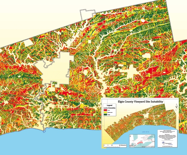
Geospatial Catalog Project Developer (Geospatial Niagara)

Developed a website powered by a server instance on Amazon AWS (EC2) using the tools listed below. CLICK HERE TO LEARN MORE ABOUT THE PROJECT. 
  • PostGIS

  • Leaflet

  • Ubuntu
  • Apache

  • PostgreSQL

  • PHP
  • GDAL

  • GeoJSON

  • JavaScript
Picture

GIS and Database Technician (OGSR Library)

Picture
The Ontario Oil, Gas and Salt Resources Library is a resource centre for the study of the subsurface geology, petroleum, salt and underground hydrocarbon storage resources of Ontario. It's principal function is to provide information services to library clientele. Library services and facilities are utilized by approximately 600 clients a year from Ontario, Calgary, Michigan, Pennsylvania, Ohio and other states. These clients represent industry, universities, the Ontario Ministry of Natural Resources and other government agencies. Part of the building is reserved for public use and can be set-up for educational and scientific workshops and courses.
Worked with MNR Geologist to update and design annual Petroleum Pools & Pipelines Map, created detailed procedural documents, generated KML files to display data for public use, gained an understanding of Ontario's Petroleum Industry, and assisted with day-to-day operational tasks as required by the Library and Library Clients. 


Academic Highlights


Picture

Bachelor of Arts Program in Human Geography with Concentration in Geomatics

Click here to visit program website!
Picture

Post Graduate Program in GIS - Geospatial Management

Click here to visit program website!
Powered by Create your own unique website with customizable templates.