Remote Sensing & Digital Image Processing
Before being introduced to ERDAS Imagine 2013, I gained practical experience georeferencing old aerial photos for the Welland Canals for the purpose of change detection. Using ERDAS, I developed my skills with image classification by creating a supervised and unsupervised classification map of a study area and then further investigated the purpose of a principal component analysis using the same study area. Finally, ERDAS was used for geometrically correcting aerial photos using the polynomial correction and orthorectification techniques. At Brock University, I developed my skills in Exelis ENVI Classic 5.0 by carrying out tasks such as data quality assessment, spectral transformations, supervised and unsupervised classifications, and accuracy assessment.
Georeferencing & Change Detection
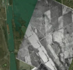
This deliverable contains a formal report in which I undertake the task of georeferencing several aerial images from 1921 and 1934 to a satellite image from 2003. This deliverable allowed me to gain the practical ability to georeference images using ESRI's ArcGIS. Georeferencing the images then allowed me to gain practical experience writing a formal report in which I conduct a change detection analysis. As a result of the completion of this deliverable, I have better understood the unique geography of the Niagara Region as it pertains to the Welland Canals.
Image Classification
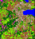
This deliverable contains a formal report in which I undertake the task of stacking multiple bands of remotely sensed imagery, creating a subset of the stacked images, and performing a supervised and unsupervised classification on the subset imagery. The final result consists of a map of the subset image and a map for each of the classifications. The report consists of a detailed methodology of how all tasks were carried out, including a statistical analysis for the training pixels that were gathered. The final section of the report discusses the different supervised classification algorithms as well as the differences between a supervised and unsupervised classification. This deliverable allowed me to gain practical experience utilizing the ERDAS Imagine image analysis and manipulation software package by applying remote sensing and digital image processing techniques.
Principal Component Analysis
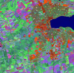
This deliverable contains a formal report in which I undertake a principal component analysis of the original subset image used in Deliverable 1 - Introduction to Supervised Classification. The report consists of the requested answers to provided questions. This deliverable exposed me to the fundamentals of principal component analysis by comparing an original image to the same image transformed to the principal component.
Geometric Correction
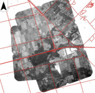
This deliverable contains a formal report in which I geometrically correct and mosaic three different aerial photos. This deliverable exposed me to the fundamentals of orthorectification and mosaic processes. This allowed the production of maps with one image of the whole area covered by all three photos. Ultimately, it is evident that the advantage of orthorectification over polynomial correction is that it takes more variables into account, producing a more accurate mosaic result.
